
Ultimate 7-10 Day Dolomites Road Trip Itinerary
The Italian Dolomites are among one of the most beautiful mountain regions in the world. It’s a part of the Alps that is extremely unique and attracts outdoor enthusiasts and all types of tourists from around the globe. If you’re planning your own trip to Northern Italy during spring, summer or fall, and are making a road trip to the Dolomites out of it, I’ve put together this itinerary that you can squeeze into 7 days or elongate to 10 days based on my own tried and true experience!
Disclaimer: This blog post contains affiliate links. I may receive a small commission for purchases/bookings made through these links at no extra cost to you.
Prior to making our way to the Dolomites, we did a TON of research and saved inspirational ideas over the year and a half that we were cooped up from the pandemic. We had originally planned to make our way to Italy in 2020 and had a basis for our Dolomites journey already drawn up, but of course our overseas trip had to be put on hold. Fast forward to fall of 2021 and we were excited to book our flight out finally! Our prior research and knowledge set us up for success for our ten autumn days in the Italian Alps and I hope they will make for a formidable visit for you too!
How Do I Get to the Dolomites?
The Dolomites are found in the northeast region of Italy and are widely known as the Italian Alps. If you’re flying into Italy with the Dolomites being your first or only destination for the trip, the two main cities you should be looking at to land in are Venice and Milan. But mostly Venice because it is irrefutably closer than Milan is (2-3 hour drive vs. 4-5 hours). And that is where we flew into! We grabbed our rental car from the Venice Marco Polo airport – a Volkswagen Golf perfect for the two of us – and headed for the mountains.
If you’re hoping to minimize your costs and forget about renting a car altogether, you certainly can! In the Dolomites, they have a bus system that will allow you to reach all the main attractions without depending on a car. Of course, this means less flexibility and a dependency on the public transit system schedule. BUT it is entirely possible and a number of people choose this plan of action! You can book your transfer from the Venice airport to the Dolomites for only €15!
Where Should I Stay in the Dolomites?
Now there are two main areas to consider staying in throughout your Dolomites trip: Cortina d’Ampezzo on the east side and Ortisei on the west. There are certainly magnificent towns and accommodations spread throughout the entire region, but finding a home base within or near the towns of Cortina and Ortisei is key to maximizing the sights you’ll get to see within your time frame. We managed to spend five nights in Cortina and five nights in Santa Cristina Valgardena, a town 15 minutes west of Ortisei.
Itinerary Breakdown
We spread our time in the Dolomites over 10 nights. We needed the extra time to rest up between excursions as Italy was on the last leg of our Europe trip, but had we dedicated 7 full days here, we could’ve made it happen. I’ve broken down the itinerary over 10 days (9 nights) for you but feel free to combine sights and activities if you’re short on time and are hoping to spend at most a week in the Dolomites.
- Day 1 – Travel to Cortina d’Ampezzo
This is a day reserved for making your way to the Alps from the city you land in. If you’re lucky to arrive early, you can spend half a day wandering the streets of this quaint town and grab a meal plus food to make for the following days. - Day 2 – Hike Tre Cime di Lavaredo & Cadini di Misurina
Our two favourite hikes piled in one day to make the most of being in this neck of the woods and paying for the daily toll road fee. Be prepared for an early wakeup and food for the road. - Day 3 – Visit Lago di Braies and other lakes near Cortina
A relaxing day to recover from the hikes by taking in the different shads of blue and green water at some of the Dolomites’ most beautiful lakes. - Day 4 – Hike to Lago di Sorapis
A third and optional hike you can add to the itinerary to reach yet another gorgeous lake and mountain. - Day 5 – Travel to Ortisei, visit Mount Lagazuoi & Passo Gardena
Head west to relocate your home base to Val Gardena. Stop along the many scenic spots that highway SS243 has to offer, including the cable car up Mount Lagazuoi and Passo Gardena. - Day 6 – Get Lost in Val di Funes & Ride Up Sassolungo
Take a stroll through the rolling meadows of this former Austrian valley and capture the picturesque churches with a gorgeous view of the Odle-Geisler massif. Head over to the Sassolungo mountain and ride up in the coffin-like cable car to reach the top of this rocky cliff. - Day 7 – Hike the Seceda Ridgeline
Ride up the cable cars to the iconic ridgeline of Seceda to hike the trails to different huts with views of never-ending pastures and mountains all around. - Day 8 – Alpe di Siusi & Lago di Carezza
Watch the sun rise over the largest high-altitude alpine plateau in Europe and the many unobstructed and breathtaking mountain ranges. Visit your final but possibly new favourite lake in the Dolomites for sunset. - Day 9 – Explore Ortisei (Bonus: Earth Pyramids in Renon)
Take a relaxing day to stroll the streets of the quaint Ortisei for your final full day in the Italian Alps, and potentially head further west somewhere off the beaten path to witness an out-of-this-world natural phenomenon. - Day 10 – Visit Lake Garda and Depart from the Dolomites
Make the most of your drive back to your point of origin by taking a day to visit Italy’s largest lake. A few stops at charming and historical towns while driving lakeside as well as checking out a beautiful church built on the side of the cliff will give you the opportunity to finish your trip in Northern Italy on a high note.
Day 1 – Travel to Cortina d’Ampezzo
Depending on where you’re coming from, whether it’s a continuation of your Italy trip or you’re just now flying into the country, make your way to Cortina d’Ampezzo for the day. You’ll likely be starting your journey to the Dolomites later in the day so simply enjoy your drive through the mountain roads, settle into your abode and grab some dinner for the evening.
There are options to do your Dolomites trip without a car – the public bus system is beneficial for those on a tighter budget and is quite dependable. You can even book your transfer from the Venice Marco Polo airport (VCE) to Cortina for only €15 per person!
But for the most ease, convenience and flexibility, I highly recommend you rent your own car for the trip. In early October, we only paid €350 for the entire 10 days to rent from the Venice Marco Polo airport. The rest of this itinerary will assume that you will be taking your own vehicle, hence your road trip in the Dolomites!
When you arrive in Cortina, depending on where you’re staying, you’ll likely have tons of well-rated Italian eats in short walking distance from your accommodations. We enjoyed freshly baked and affordable thin-crust pizza from Ai Due Forni a couple of times throughout our stay and we grabbed delicious and hearty sandwiches for the next day’s hikes from Molo Cortina. Take this evening to rest up and prepare yourself for what’s to come!
There are many cozy hotels and vacation rentals you can stay at in Cortina d’Ampezzo. We stayed right in town along Lago delle Poste which was perfect. Just a short walking distance from the grocery stores CONAD CITY and La Cooperativa, as well as all the good eats in town. If you’re craving some mouthwatering Italian pizza, you can just walk out of your accommodations and into the piazza for some!
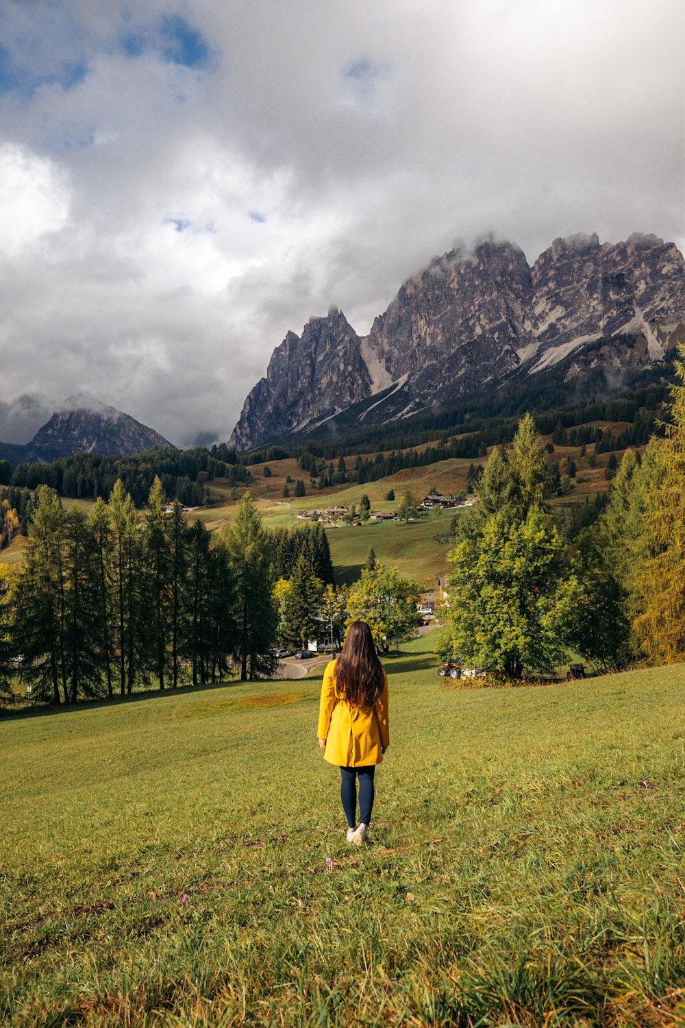
Day 2 – Hike Tre Cime di Lavaredo & Cadini di Misurina
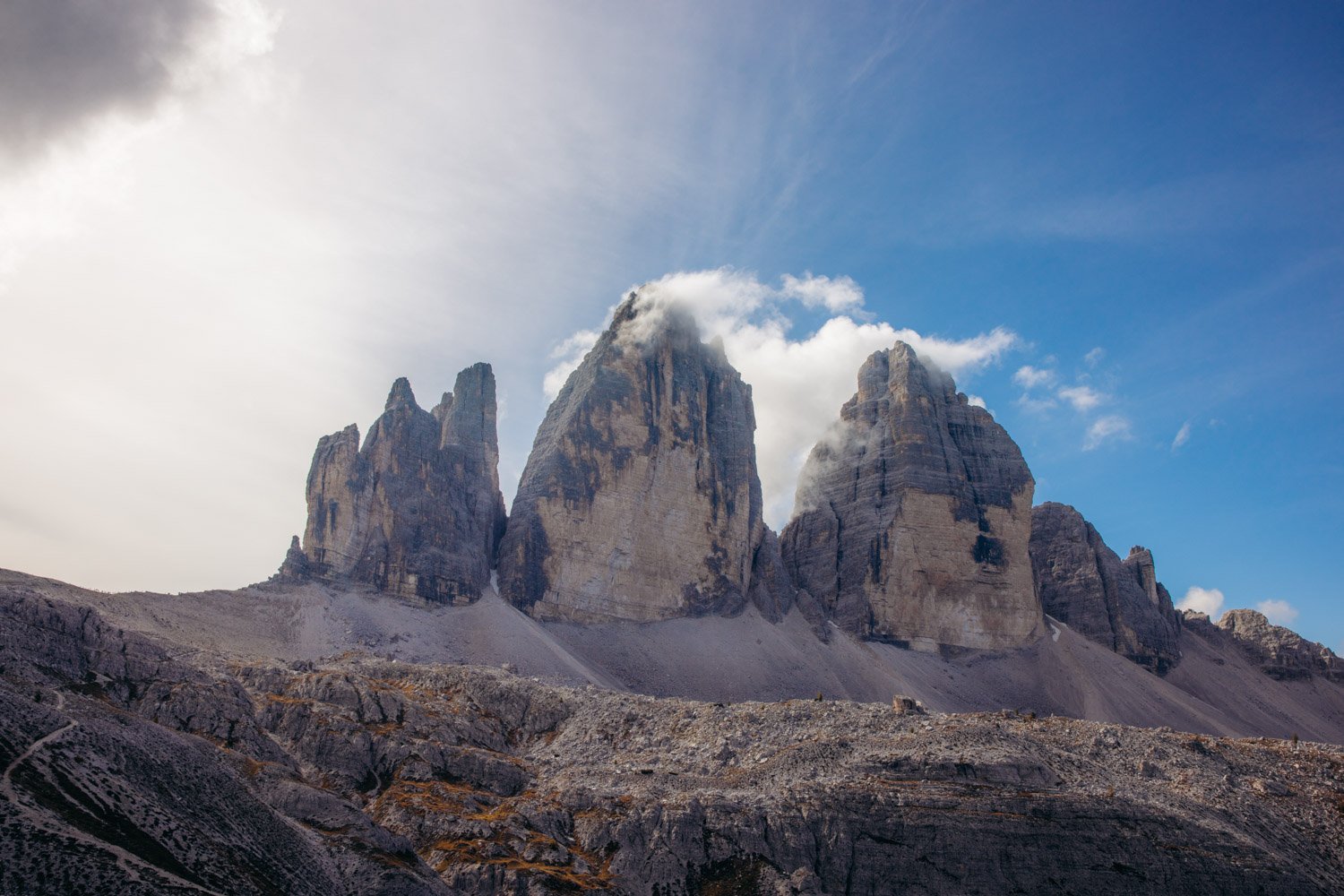
Tre Cime di Lavaredo
Start your first full day in the Dolomites on a high note with the iconic three chimney peaks: Tre Cime di Lavaredo (Drei Zinnen). This circuit is by far the most popular hike of the region and demands that you come see it for yourself. The hike is deemed easy to moderate with 10 km in length, 340 m in elevation gain and about 3-5 hours to finish the circuit. This was one of the best hikes we’ve ever been on and I highly recommend saving up a morning to do it! You’ll be glad to come to the area for a sunrise treat over the mountains and valleys, and not have to scramble for parking or deal with high heat in the middle of the day.
If you want to come up to this point for the views without doing the hike, by all means go for it. The mountains are gorgeous and you can see them from the trailhead at the Rifugio Auronzo.

BUT you won’t really get to see the Tre Cime peaks in all their glory. In order to see the iconic frame of the three peaks, you’d have to continue on the trail. The counter-clockwise loop follows trail 101, passing Rifugio Lavaredo and reaching the Forcella Lavaredo junction where you’ll get your first side-view peak at the peaks (pun may have been intended). This is also where you’ll cross the invisible line that brings you to the South Tyrol region of Northern Italy.


The Tre Cime hike offers beautiful sceneries throughout, our favourite being at the Dreizinnenhütte – or Rifugio A. Locatelli/S.Innerkofler.
Once you reach Forcella Lavaredo, keep right and follow the trail down that continues on 101, passing on the west side of Monte Paterno (Paternkofel) to reach this serene refuge. This will be your first time crossing into the South Tyrol region, an area that once belonged to the Austrian Empire prior to the end of WWI.
By Dreizinnenhütte, there’s an immense valley to gaze down upon, two calm and reflective lakes called the Laghi dei Piani and surrounding mountains that you wouldn’t have been able to see from the trailhead. We spent a good two hours here it was so peaceful! Tons of folks continued climbing upwards to reach these cave windows situated within mountains northwest of the hut. I could only imagine the view they got of the three peaks through these rock windows!


The rest of the loop trail is incredibly well defined and captures different points of view of the Tre Cime, follows the beautiful valley to other mini lakes and a third rifugio called Malga Langalm, and we were all for it! But there’s another iconic hike you have got to do before the afternoon comes to an end.
Cadini di Misurina
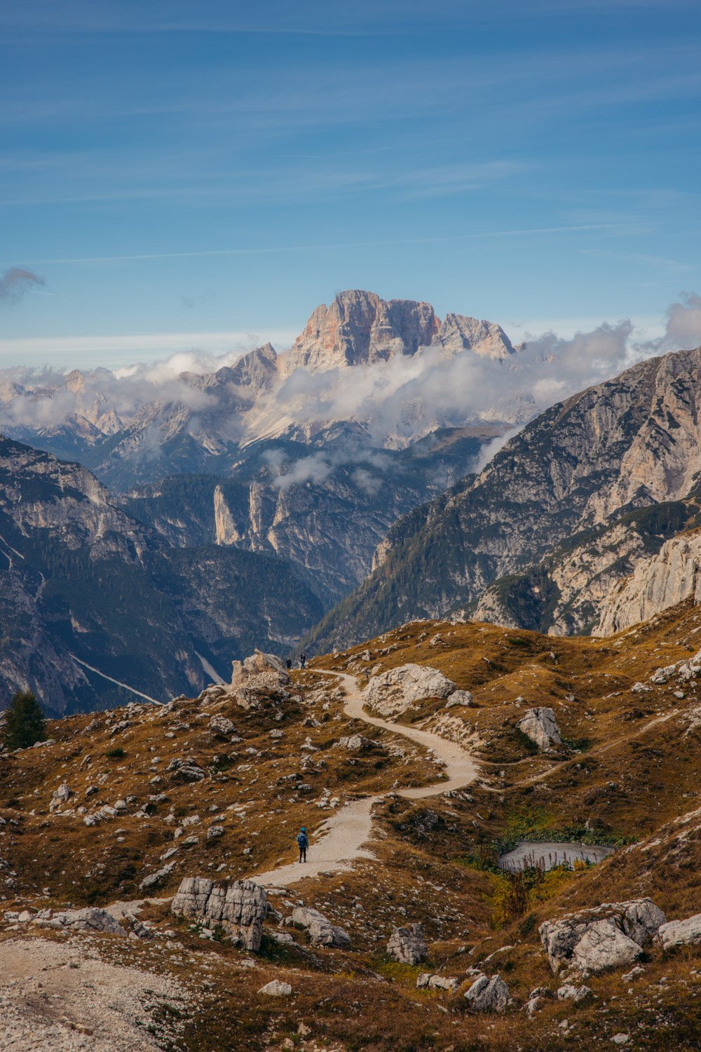
The Cadini di Misurina is a short out-and-back trail that leads you to a marvellous and incomparable vista point that you will never forget. It is one of the highlights of this entire Dolomites itinerary and I hope you get the chance to complete it before leaving the Tre Cime area.
From the same trailhead you were at at the beginning of Tre Cime di Lavaredo – Rifugio Auronzo – you’ll begin your hike heading southwards this time, away from the three peaks with your back facing them. The hike is less than 2 km one-way and about 120 m in elevation gain so you might feel the steepness in your lungs and legs. The trail may split here and there so always be on the lookout for red and white striped pole markers and keep following signs for trail 117.
Not long after starting the hike, you’ll already be greeted by the marvellous spiked peaks that make up this phenomenal mountain group. You’ll also be able to spot some gems down below in the valleys as this hike in entirely exposed with no visual obstructions. The trail is mostly made up of loose rocks and dirt and because the final path to reach the iconic viewpoint consists of a narrow edge adjacent to a drop-off and ends with a narrow ridge, it’s highly recommended not to complete this hike when the soil is wet from recent rain and precipitation. The trail can get quite slippery so reserve this hike on a clear day where it hasn’t rained recently.


The hike really is about the final destination at the end of the ridge. You might arrive and notice others at the vista point already or be lucky to have it all to yourself. It’s intensely humbling to stand at the edge that point amidst the panorama of these formidably jagged peaks often referred to as the Towers of Mordor. Sunset would be a gorgeous time to be shooting at Cadini di Misurina, but anytime throughout the day this place will take your breath away.


Important note: To reach Tre Cime by car, there is a 30€ toll fee in order to drive a car up and park at the trailhead (it’s 20€ for motor-vehicles and 45€ for camper vans). The fee can be paid by cash or card, but fair warning, sometimes the connection is too poor for the card machine to function. The private toll road is open 7am-7pm in the summer months and 8am-6pm in the shoulder months (June and mid-October), however the arm was open to let traffic through when we reached the booth at 6:15am. You can always exit the park after the allocated closing time.
There are alternatives to this expensive toll fee if you’re looking to save money. 1) you can park in the free car park at Lago d’Antorno and hike up to Rifugio Auronzo (about 90 minutes with 500 m of elevation gain – a strenuous hike). 2) you can take a shuttle bus from various locations, the closest being Lago di Misurina. The roundtrip cost is 16 per person (one-way is 10) and you may be limited in flexibility with the bus operation times, but it could be advantageous if you’re riding solo.
Day 3 – Lago di Braies, Lago di Dobbiaco, Lago di Landro & Lago di Misurina
Though the Dolomites have but a few easily accessible lakes, each one of them is picturesque in its own way. Whether it’s water colour, mountain views or on-water experience, each lake is distinguishable and worth a visit.
Lago di Braies
If you’ve heard of the Dolomites, you’ve probably already seen images of the Instagrammable Lago di Braies (Pragser Wildsee) plastered online. Is it deserving of its given title “Lago di Instagram”? I would say, yes! The Seekofel massif surround the lake and have incredible rocky and alpine features. The water reflects a deep emerald colour and shines a brighter turquoise in the sun. If you come to the lake early in the morning around sunrise and there’s no rain, you’ll catch a pristine reflection of the imposing mountains on the green water as well as the rustic Italian boats that line the shore.
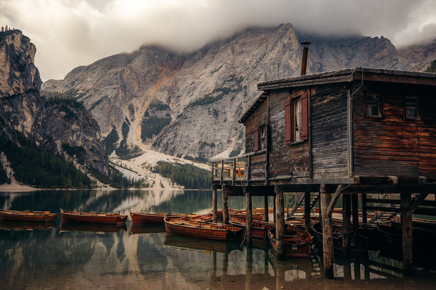
Our favourite feature of this lake, and likely a huge tribute to why it’s so popular, is the fact that you can take out one of these classical row boats onto the water. The rowing manoeuvres might take some getting used to, but once you get the hang of it, you’ll be flowing in a sea of emerald. Opening hours for the boat rentals vary throughout the season, and even though the sign said “opens at 9am” the day we came, the attendants let us know it wouldn’t be open until 10am. Regardless of the long wait, it was well worth it for us to be there early and at the front of the line.


Check out their website for up-to-date pricing and hours! There are two prices: one for 30 minutes and one for an hour. You pay upfront for the hour and if you only row for half the time, you’ll get the remainder refunded. They only took cash at the time so have the amount of cash ready for your rental! After rowing and docking the boat back, you’ll be able to exit through the hut and select a couple of many amazing Lago di Braies postcards as souvenirs!
Lago di Dobbiaco
An underrated lake also situated in the South Tyrol region like the aforementioned lake, is Lago di Dobbiaco (Toblacher See). This lake is very much worth the stop as it’s just off the side of the SS51 road coming back towards Cortina from Lago di Braies, about a 25-minute drive from the other lake. Its tranquility brings all the cute ducks swimming along the shoreline and the deep green-blue colour is formidable to look at. I loved that the colour separation between the shallow green water by the north edge and the deeper blue was very apparent. On a non-windy day, you could also see right to the bottom in the shallow section as if the surface were glass, and spot some tiny fish swimming through the pond weeds.
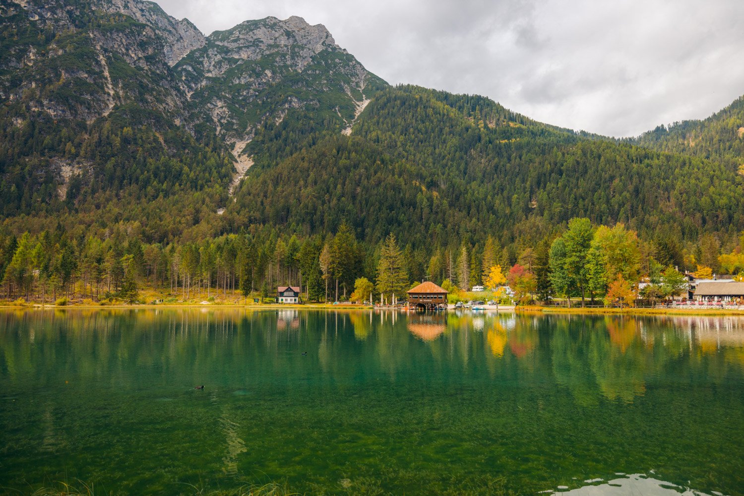
The best view in my opinion is from the north shoreline just a short walk from the parking lot. It also makes for the perfect framing for photography. In this frame, you’ll be able to capture the two different colours of the water as well as the picturesque alpine mountains that are so ideally placed to create a V-shaped valley in between.
Though Lago di Dobbiaco doesn’t often show up on Dolomites visitors’ radars, I was so glad we got to witness its glory and hope you will too. If you’re keen to spend more time here, you could take a light 45-minute stroll around the whole lake, rent a pedal boat for €8/€15 for 30 minutes/1 hour (pricing subject to change), or enjoy a lunch at Seerestaurant (Ristorante al Lago).
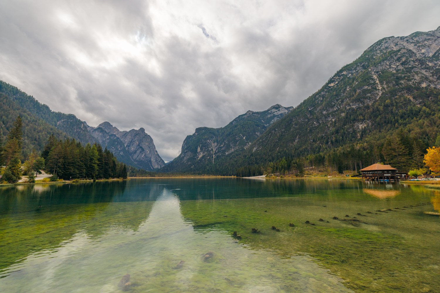
Lago di Landro
Another 10 minutes south of Lago di Dobbiaco is a stunning glacial lake called Lago di Landro (Dürrensee) right next to the same road, SS51. The colour of the water is drastically different from what you’ll have seen so far at the other lakes, as it shines a pastel aquamarine. As the season progresses from summer to fall and later to early winter, the colour will get lighter and lighter as the lake recedes. The reason for this vibrant colour is thanks to something called glacial wash, which is essentially rock flour carried in the glacial melt that trickles down to the lake. And the bright pastel tone is due to the lake sitting on a light grey clay-like soil.
As the lake recedes in autumn, you can walk actually along the shoreline on the wet clay – it definitely gets sticky and slippery to wear good traction shoes if you do! The light pastel blue colour was something, but the captivating sharp multi-peak mountains of the Cristallo massif most definitely caught our attention. This was also our first spotting of fall colours which we found on the south side of the lake in the foreground of the majestic mountains!
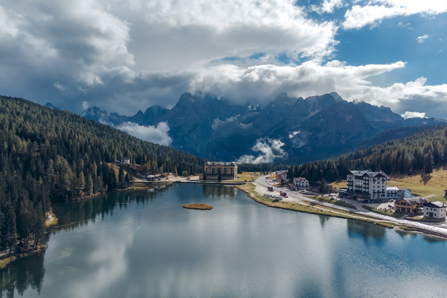
Lago di Misurina
The final lake to visit on this day is just another 10 minutes south from Lago di Landro, yet again located right off the road, this time on SP49. Lago di Misurina is one of my favourite lakes and there’s no wonder why there are a number of chalet-style hotels situated around it. This lake has a gorgeous deep blue colour and the water surrounds this cute little island in the centre. There are imposing rocky mountains that completely envelop the lake, so it was neat to walk around the shore to get different vantage points where we captured various beautiful frames that pictured glistening water in the foreground, an Italian chalet hotel in the centre and striking peaks in the background.


The award-winning view, however, goes to the south shoreline because the Sorapis mountains are just so remarkable. You can best capture this view from the north parking lot along Via Guide Alpine, the same location you can rent a row boat or pedal boat if you’re hoping to take in more of the lake from the water. If you manage to visit Lago di Misurina on a day where it just rained, you’ll be lucky to watch the clouds rise behind the south building on Via Monte Piana and above the valley that separates the lake from the magnificent Punta Sorapis.
Note: You’ll notice that after leaving the South Tyrol region and being back in Veneto, the places you visit no longer have a German name as well an Italian. Lago di Misurina is one of those places. Some landmarks in South Tyrol also have a third spelling which is in Ladin, which is the parent language of South Tyrol. The language has been spoken for a thousand years and is still spoken today by 18,000 people in the Val Badia and Val Gardena valleys of the Dolomites.
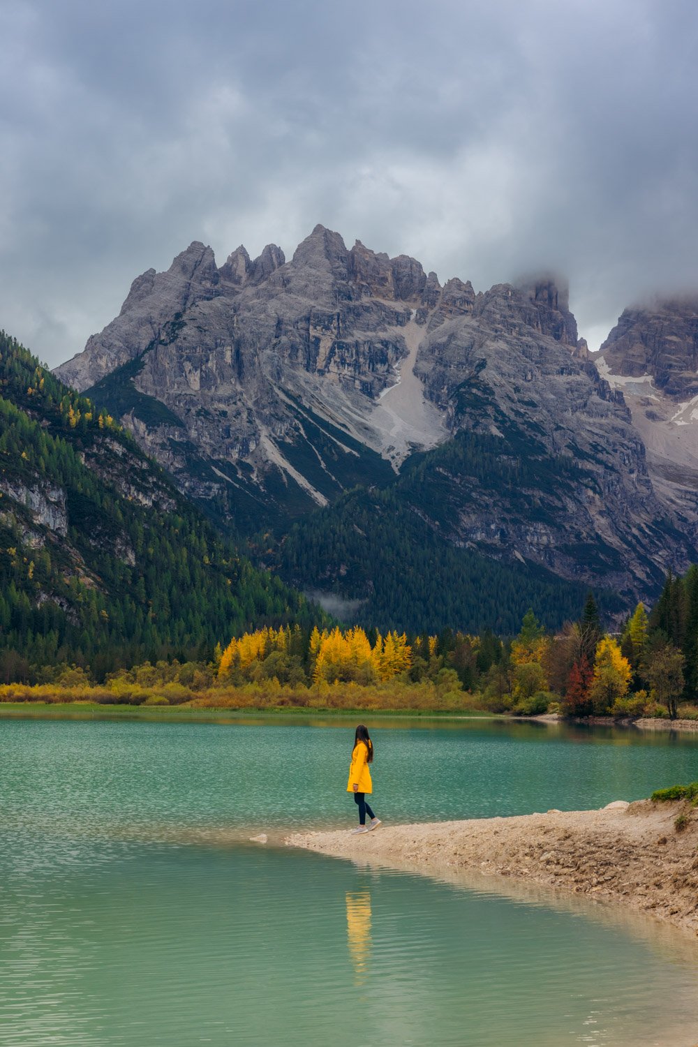
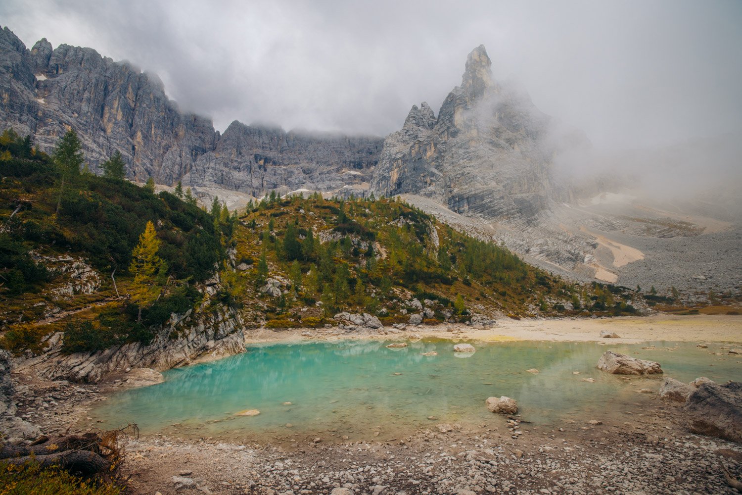
Day 4 – Hike Lago di Sorapis
If you have the time and energy for a third hike on this trip, Lago di Sorapis is a stellar lake to trek to. A glacial lake much like Lago di Landro, this body of water does dry up in the winter months but is an absolute gem of a crystal blue lake in the summer and early fall. Hiking this trail in early October was still a valuable experience for us even though the lake had receded, but I’ll let the pictures speak for themselves and you can decide if it’s worth the trip for you depending on the season you’re visiting the Dolomites.
The trailhead for Lago di Sorapis can be found at Passo Tre Croci, a mountain pass just 15 minutes east of Cortina d’Ampezzo. There’s a dedicated free parking lot situated along road SR48 about 850 m before the trailhead if you’re coming from Cortina, but if you’re coming here early in the day, you can park right on the road’s shoulder beside the trailhead.
The trail is incredibly well defined with clear signs for trail 215 as well as red-white-red horizontal striped markers painted along the way. Trail 215 takes you straight to Rifugio al Sorapis A. Vandelli, the hut/teahouse located just minutes from the alpine lake, and leads you on an out-and-back hike. Roundtrip, the hike is about 10 km in length and 430 m in elevation gain, and is considered to be moderate in difficulty.
The hike can also be extended into a circuit by climbing a steady ascent along the mountain pass following trail 216 back home, but this route is more technical with some scrambling, and steep with about another 400m in elevation gain. If you’ve got the energy to complete the circuit, then by all means do it! But we only came for the lake view and chose, just like the majority of folks, to hike the same way back down.
The trail starts off very easy and flat and about 15 minutes in, you’ll come across a fork in the road. The most instinctive path heading upwards on the right is in fact not the right way to go, and it’s clearly blocked off with a line of rocks placed across. Take the left path heading down the slope and you’ll be on the right track. The trail continues through the woods and we experienced quite the fog passing through here, but as we emerged through to the cliff edges, we started seeing faraway mountain peaks make an appearance above the clouds and it was phenomenal!


Because of some narrow ledges towards the top of the trail, we recommend only hiking to Lago di Sorapis if the terrain isn’t wet. So avoid rainy days as well as days after which it rained. The ledges aren’t guarded on the cliffside but the rock walls are guided with metal cable handrails. Though I often have nervousness around unguarded heights, I barely felt that on this hike. The trail is definitely steeper in the second half versus the first. But it was easy to pace ourselves, especially with the trail being flat in some sections along the ledges, sometimes traversing wooden plank walkways. Towards the top, you’ll have some metal stairs to climb but nothing crazy and you’ll likely forget the physical effort because you’ll be so distracted by the many layers of mountain views.


Finally, you’ll make it to Rifugio Vandelli and a little further you’ll spot the vibrant turquoise lake and the towering 3200m Mount Sorapis. The Lago di Sorapis hike has a short window in the summer season, starting in July as the snow melts and ending in September when the water recedes. But even in early autumn, there were no regrets for making the beautiful trek up.


Day 5 – Travel to Ortisei, visit Mount Lagazuoi & Passo Gardena
Now that you’ve spent the last few days visiting some spectacular sites on the east side of the Dolomites, it’s time to make your way west towards Ortisei. Day 5 would be spent taking this scenic drive up and down the valleys and stopping at the eye-catching spots that call out to you along the way.
Having the freedom to simply drive and allow your eyes to have control where you stop, even if it’s a random spot, brings a certain kind of joy of appreciating the present. But to give you an idea of what to see en route to Val Gardena, here are a couple spots you can start with.
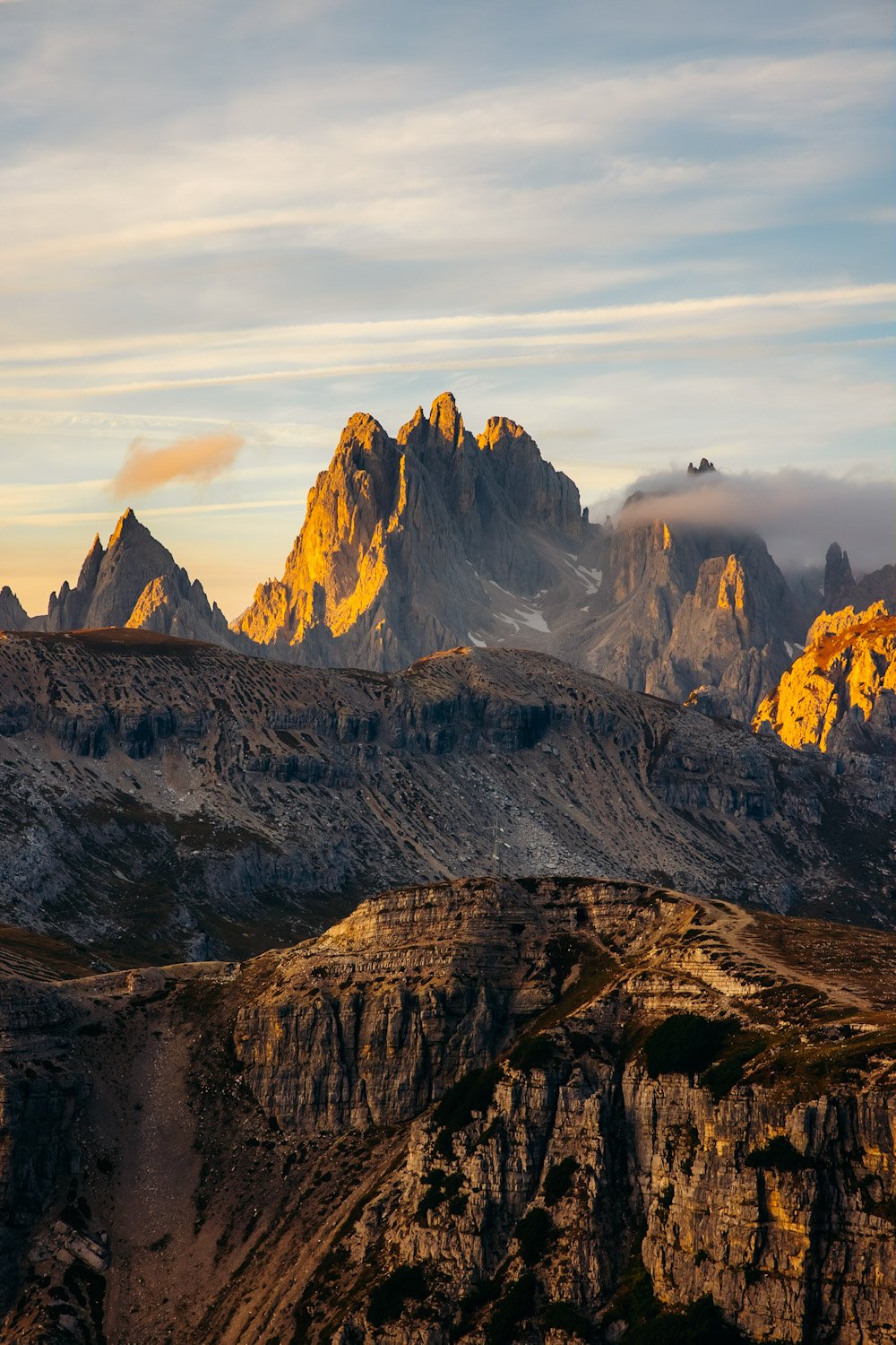
Mount Lagazuoi
For the history buffs, Lagazuoi Mountain is a top place to be if you want to immerse yourself in WWI history. There’s a cable car that can take you up the mountain where you’ll be in the thick of incredible scenery and be able to walk through the carved out tunnels that the soldiers mined over a century ago. They’re not incredibly advertised but we easily came across a wooden door near the top of the cable car that led us into a cave where there was actually a sniping rifle set up (you can access it of course as it’s barred off). It’s quite the open-air museum, and it’s pretty neat to find yourself in these tunnels where Austrian and Italian soldiers had once set up camp.


The cable car cost varies throughout the summer months and you can check out the new pricing here. It’s one of the only cable cars that remains open later into the fall – from early June to late-ish October. If you’re a keen hiker, you can hike from the gondola parking lot instead, meeting further tunnels and suspension bridges along the way. To our surprise, there was quite a bit of snow and ice that accumulated at the top which we weren’t prepared for. So a word of advice from our experience, always wear your hiking boots when making it up to mountain tops in the Dolomites if you’re not coming in the dead of summer.


The views up here are really something else and they reminded me of home in the Canadian Rockies. You could also spot the Cinque Torri (meaning “five towers”) from up here, another well known hiking area with WWI history to explore. You’d have passed by the Cinque Torri rock formation on your way to Lagazuoi from Cortina on the south side of SR48. It’s a great option for a sunrise hike if you have the time and energy this day, as it’s categorized as relatively easy, or you can simply ride the chairlift which is operational in the summer months from 9am to 5pm – check here for updated pricing.
Back to where we were at the top of Mount Lagazuoi. If you’ve worked up a hunger, you can keep enjoying the panoramic views and a good meal at Rifugio Lagazuoi before heading back down the cable car.
Passo Gardena
One of the most gorgeous mountain passes we’ve ever driven through goes to Passo Gardena (Grödner Joch / Ju de Frara). It was slow and steady as we drove up the steep and winding road that lead us up from Val Badia to the beautiful pass before we made our way down to Val Gardena.
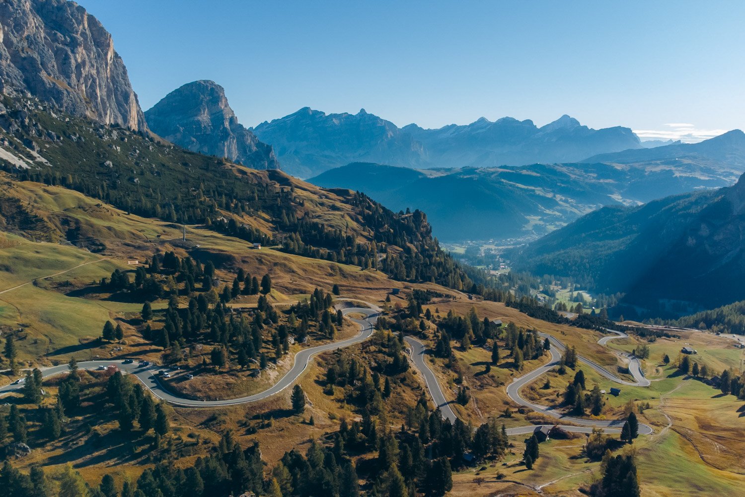
We couldn’t hesitate to get out of the car and adventure through the high-elevation mountain pass on foot. You can park at Rifugio Frara and from here there are a number of trails you can follow to get different vantage points of the 360-degree vista. It’s a fantastic place to stretch out your legs during the drive to Ortisei or to spend a whole day out hiking in the vast mountains of Northern Italy with few people in sight. If you’re hoping to prioritize Passo Gardena on your way westward, consider doing a hike from here like Cima Pisciadu, or test your fear of heights by doing the rock climbing via ferrata at Gran Cir or Piccolo Cir (a.k.a.”Big Cir” & “Little Cir”), provided you have the proper climbing equipment!
Exploring the area might call for some good food to refuel with. We personally loved dining at Hotel Chalet Gerard, just 7 minutes further down SS243 from Passo Gardena, and indulging in some tasty pasta before ending our day in Ortisei.
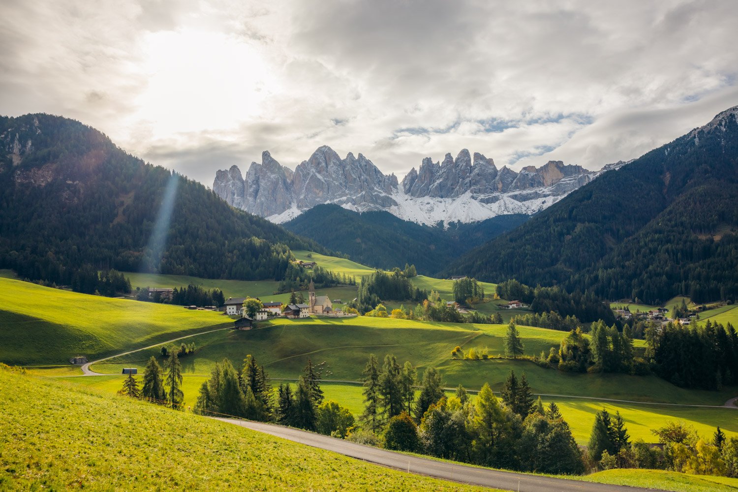
Day 6 – Get Lost in Val di Funes & Ride Up Sassolungo
Val di Funes
Towards the north side of the Dolomites is a stunning valley that’s known to show off the Puez – Odle (Geisler) massif like a crown jewel. Val di Funes (Villnöß) is one of the quaintest areas in the Italian Alps and it is home to two monumental churches in the most scenic backdrop.
Santa Maddalena
The medieval Santa Maddalena (or St. Magdalena) church sits atop a vast hill overlooking the town homonymous village of Santa Maddalena. Though it’s a small structure, its gothic architecture makes for such a picturesque view at the forefront of the storybook Villnöss valley with the majestic Odle group (Geislergruppe) lining the back. To visit the church, we found the best and closest place to park was here as you can’t drive up and park at the church itself. We then followed an easy-to-follow uphill walking trail to the church and continued further on for some great photo opportunities.
The trail from the church is actually a paved road for local traffic, so it makes it easy to stroll on for however long you want. We didn’t walk very far – maybe about 10-15 minutes from the church – but noticed the few other folks who were here this morning did continue and followed other trails through the woods uphill. It’s one of the places I felt the most at peace in our entire Dolomites trip. Hearing nothing but the sheep “baa” and the cowbells ring makes you truly appreciate being in this Austrian-Italian countryside.
Note: If you need to use the restroom in this quiet town while no shops or restaurants are yet open, there’s a very clean, public bathroom you can use right beside the church on your way back down that you can use for free. You can leave a small donation in the attached donation box if you’d like!
St. Johann in Ranui
The baroque St Johann in Ranui church lays on a flat pasture on the southeast side of the small mountain village. We managed to park here at the small lot situated within a bus station, just a 3-minute drive from where we parked for St. Magdalena. Visiting St. Johann in Ranui was as easy as crossing the road from the car park, where a constructed photography platform was built. I think the reason for why the locals built this viewing area is because it prevents overzealous tourists from hopping the fence onto private pasture land to snap their photos. Though we felt restricted because we couldn’t get any other vantage points to capture the beautiful structure along the road, it was honestly the best vista anyway.

My recommendation for Val di Funes is to come bright and early to avoid the crowds and to truly feel like you’re living your Sound of Music dream – or was that just my dream? If you wanted to discover more that St. Johann in Ranui has to offer and be able to get close up and personal with the landmark, you could also visit the church with an entrance fee of €4.
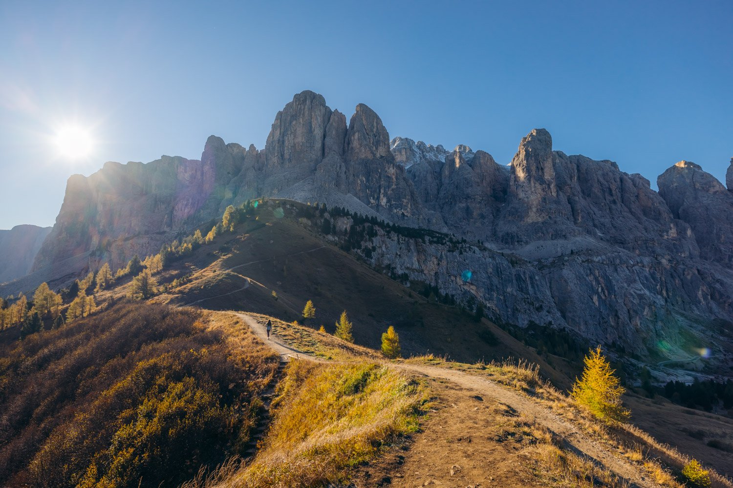
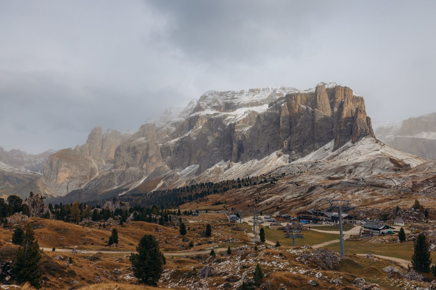
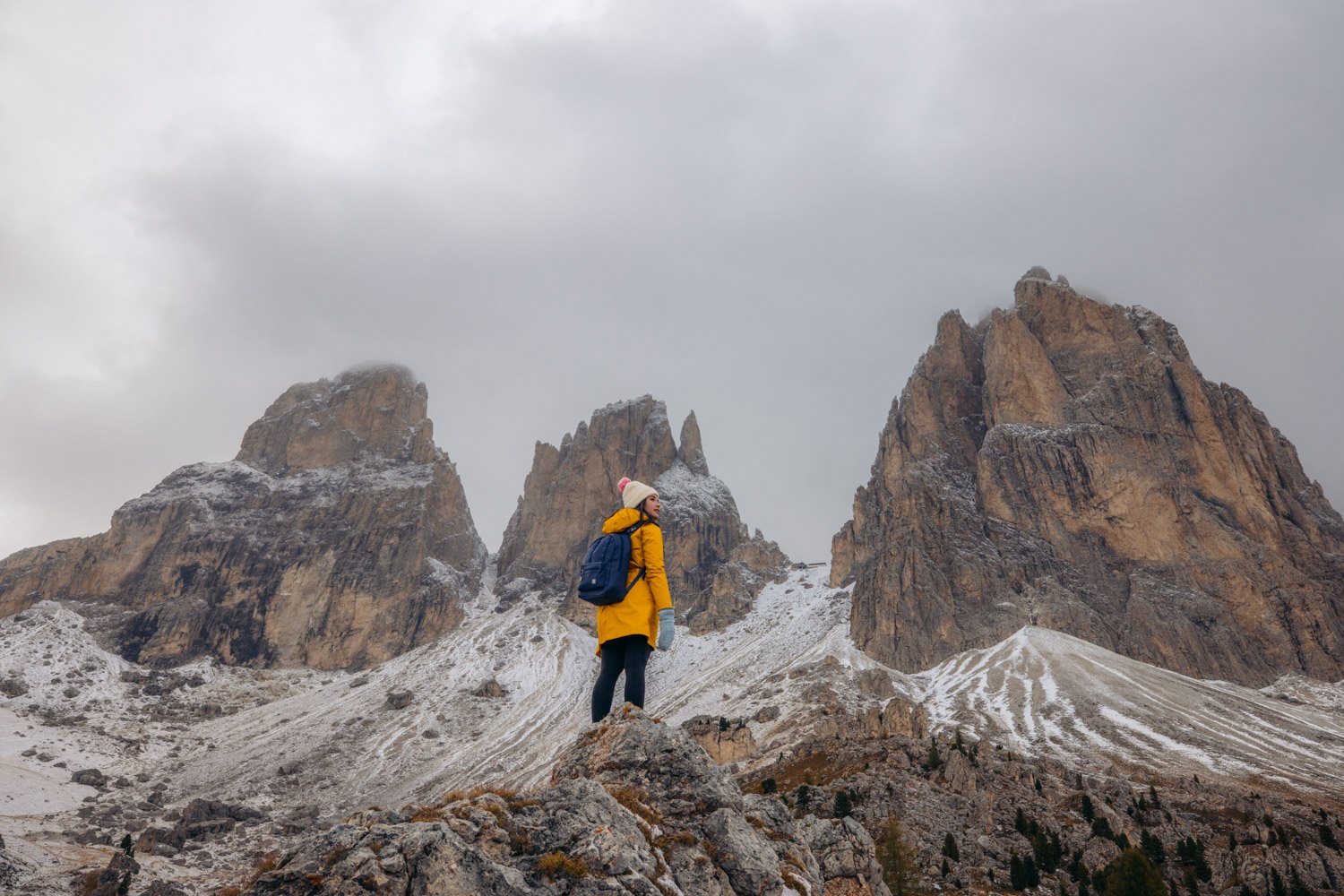
Sassolungo Mountains
About an hour’s drive south from Val di Funes, you’ll come to a vast mountain pass called Passo Sella (Sellajoch). You might start recognizing some of the mountain ranges in the area and that’s because it’s only 15 minutes away from Passo Gardena which you would have passed through the day before.
The Sassolungo (Langkofel) mountain group is one of the most iconic ranges in the entire Dolomites. You’ll be spotting them a lot throughout the rest of your road trip when you’re at the top of the Seceda Ridgeline, hiking through the meadows of Alpe di Siusi and even from the town of Ortisei. The name Sassolungo means “long stone” which is a pretty spot on description of the rock formation that makes up this range. The massif is spread across the earth in a distinctive C-shape arch that opens up to the northwest, which you can see on Google Maps in the terrain view. This is why you’ll have a different view of the Sassolungo group from Passo Sella than you will when in Val Gardena.
You’ll be starting your journey up Sassolungo at the (paid) parking lot across road SS242 from the Hotel Passo Sella Dolomiti Mountain Resort. You may be able to park for free at this mountain resort or the Chalet Sella instead, depending on whether the lot is open for cable car visitors. At this point, you’ll already be greeted with marvellous views of the Sassolungo group on the west and Sella group on the east.
After parking, make your way the cable car station, Telecabine Gondelbahn Forcella del Sassolungo. This will be a highly memorable ride to the top of a mountain if you decide to opt in for the cable car. It’s the most unique gondola I’ve ever seen and consists of a two-person maximum coffin-like lift in which you can only stand the whole way up, and it does NOT wait for you. In order to get on, two attendants would assist you and you’d have to run and jump into the car as it’s moving one at a time. Seems like a lot of fun, or daunting for some!
The cable car would take you all the way up to Forcella del Sassolungo where a lodge called Rifugio Toni Demetz Hütte is insanely built at the base between two monstrous mountains – Mount Sassolungo (Langkofel), the highest peak that the group is named after, and Punta delle Cinque Dita (Fünffingerspitze). To the left of Punta delle Cinque Dita is the second tallest peak out of the five mountains that make up this group. This peak is named Punta Grohmann (Grohmannspitze or Mount Sasso Levante) after Paul Grohmann, an alpinist who in 1869 was the first to conquer the five summits.
Sadly, the Forcella del Sassolungo cableway is the first to close in the fall so it has a short-lived season. You can check the timetable and pricing online for the various cable cars and chair lifts that ride up Sassolungo. If you’ve missed the window and want to venture around the lower parts of the valley, you can roam around the “City of Boulders” (Città dei Sassi / Steinerne Stadt) where the diverse flora and pines thrive.
A popular circuit hike here you can do in the summer follows trail 525 and goes up the steep and challenging 467m to Forcella del Sassolungo, down the demanding descent to Rifugio Vicenza (Langkofelhütte), makes its way north along trail 526 or 526A reaching Rifugio Emilio Comici, and then continues on trail 526 through the Città dei Sassi to close the loop at Passo Sella. There are many other trails of different levels of difficulty that start from Passo Sella that you can take depending on the challenge and mountain views you want to give yourself.
Day 7 – Hike the Seceda Ridgeline
One of the very major reasons for why the Dolomites was at the top of our bucket list is the famous Seceda Ridgeline. Nothing has ever compared to hiking along the jutting angular mountain peaks lined with green grass all the way to the edges, with vast valley views on one side and endless meadows and and mountains on the other. This was a must-do for us and I hope I can convince you of the same!
The easiest and fastest way to reach Seceda is by taking the Ortisei-Furnes-Seceda cable car. It’s not the cheapest way at a whopping €35 roundtrip when we went (visit here for up-to-date pricing and scheduling), but it’s worth it to save the time and energy for up there. The large parking garage is located right in Ortisei making it double efficient. The first ride (Ortisei-Furnes) consists of a four-person gondola that comes one after the other every few seconds. Once you reach the halfway point, the large bus-like cable car (Furnes-Seceda) comes every 15 minutes and groups of around 20 people at a time. From there, it only takes about 10 minutes to hike up to the first point of the ridgeline.
You could spend endless hours getting lost at the top of the Seceda spires, grabbing the best view at Forcella Pana (Panascharte) and keep continuing along the Odle and Puez peaks as long as you desire. That’s right, what you’d be hiking along are the jagged peaks that you saw from Val di Funes! You might even be able to see into the valley on your left towards the north.


I found it crazy that at such a high elevation in what I would think is a remote area, there were tons and tons of huts dispersed through the grassland towards the south. You’ll likely never go hungry or without shelter if you needed it thanks to all the abundant restaurants that were only walking distance away. This is why some choose to take the Col Raiser cable car from Santa Cristina Valgardena and hike the scenic route up instead, passing many huts along the way to enjoy a meal with a view.

For many photographers chasing Golden Hour, or simply wanting to avoid crowds, and who are up for the challenge can hike all the way up to the Monte Pic summit and Seceda Ridgeline from this small car park in Santa Cristina. If you are keen enough for this climb of at least 750 m for sunrise, you could also take the cableway back down with the Fermeda line, hike a short way east and hop on the Col Raiser down. The walk from the bottom of the latter cable car to your original starting point beats hiking back all the way down from Seceda, unless that’s your thing.
Day 8 – Visit Alpe di Siusi & Lago di Carezza
Alpe di Siusi
You can’t leave the Dolomites without traipsing through the largest high-elevation alpine plateau in Europe. At 52 km², Alpe di Siusi (Seiser Alm) spans so far that it meets multiple mountain ranges. The most famous of course is going to be our beloved Sassolungo (Langkofel) group, now showing off the Mount Sasso Piatto (Plattkofel) meaning “flat stone”. The altitude of Seiser Alm varies between 1680 m and 2350 m as it is spread across such a vast distance.
The best time to visit Alpe di Siusi photography-wise is in the evening for sunset, as the sun hits the Langkofel range to make it glow orange. During sunrise with harsh lighting, the mountains can be back-lit, but coming early in the morning allows you the time to adequately be present in the meadows without rushing to beat the light disappearing. We decided to come for sunrise for that reason and as the day progressed, we made the most of it: walked along trails with no one in sight, greeted some cows grazing, found a bench with a view and enjoyed a light meal just the two of us.


Important note: There are a number of ways to reach Alpe di Siusi, the best method in our opinion being slightly restrictive. Our favourite is by way of driving all the way to Compatsch. But here’s the thing: the road up the mountainous road for incoming traffic to Compatsch is closed from 9 am to 5pm daily. The good news is that you can drive back down at any time of the day. The not so good news is that parking costs €19 for the day (2021 pricing), but the lot is conveniently situated here.
If you’re not wanting to drive up or you prefer the flexibility of visiting Alpe di Siusi further in the day, you can take one of two different cable cars. 1) The one that gets you closest to the best viewpoints and comes from the east is the St. Ulrich – Seiser Alm line that comes directly from Ortisei and lands you at the Mont Sëuc cable car station (pricing and timetable here). 2) The one that gets you to Compatsch and comes from the west is the Seis – Seiser Alm line that comes from the town of Siusi (Seis) (pricing and timetable here).
We arrived at Compatsch at the early hour of 5am when the stars were still twinkling. We brought our headlamps to hike in the dark, and thankfully, the trail is incredibly flat and well defined with a wide, paved road. The reason for this is because it is meant for cars to drive through, as well as horse carriages which you may see trotting through in the day. As there are a number of huts that people vacation at during the winter months for skiing, and mountain resorts like the ADLER Lodge ALPE, this would be the only way guests would be able to come through. They receive an exclusive permit to drive up the road from Seis to Compatsch at anytime solely on the day they check in.
It was incredible to watch as the frost evaporated and the fog lifted off the green meadows that morning when the sun started to rise on the left side of Sassolungo. It made the hour trek in the dark dodging cow poop here and there worthwhile. The best view in the rolling meadows is at Belvedere dell’Alpe di Siusi, which is where a bunch of us photographers conglomerated. It’s a super spacious area so you’ll never have to fight for a spot! We also wanted to check out this swing located at Malga Sanon which is a great place to grab a meal after hiking around before heading back to your point of origin.


On the way back to Compatsch, we noticed how much the plateau was chair lift galore. We also got to witness the Sciliar (Schlern) massif in all its glory against the blue sky.
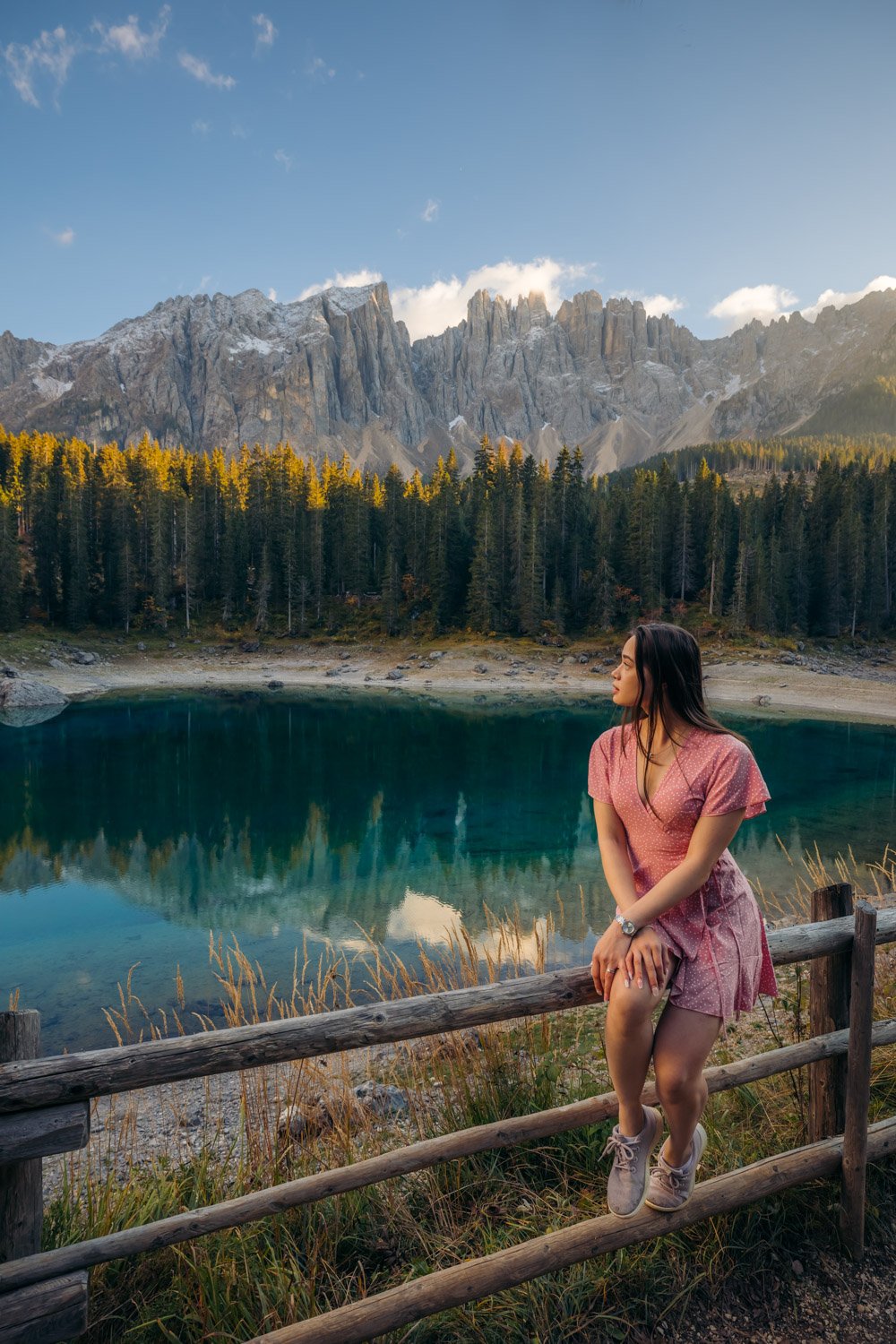
Lago di Carezza
I didn’t think I’d come to this conclusion, but I might have to say that this lake is tough competition for Lago di Braies to be the most breathtaking lake in all of the Dolomites. About an hour south of Ortisei, we come to a surprisingly isolated body of water called Lago di Carezza (Karersee) and it might just be our favourite lake in the Dolomites. It’s relatively small and you aren’t able to get close to the water, but its intense, glistening emerald colour with the sharp peaks of the Latemar mountain range in the background make for one of our most adored sights.

An ideal time to visit is around sunset where you’ll see the orange colour gleaming against the mountain peaks. You can walk around the lake to get different vantage points, but since it’s such a short walk, we recommend bringing a light meal here and grabbing a seat at the wooden benches to enjoy the view as long as you can. It can get crowded in the evening as there’s little space along the perimeter of the water, so if you want to come earlier if you’re visiting during the peak summer months, by all means do it.
The parking lot is across the road and is subject to a fee which you pay at the machine to validate your ticket right before you leave. There are different facilities here at this tourism information centre, including restrooms, and after parking you’ll be lead through an underground pedestrian tunnel that leads you to the other side of the road where you’ll see the hidden lake of Carezza.
Day 9 – Explore Ortisei (Bonus: Earth Pyramids in Renon)
Ortisei
The town of Ortisei (Urtijëi / St. Ulrich) is one of the most beautiful towns in South Tyrol and you could spend a few hours aimlessly wandering the narrow streets, grabbing a strong espresso with an Italian/Austrian meal, and visiting a few beautiful churches while playing peekaboo with the Sassolungo range.

One of the cutest chapels I’ve ever seen is St. Anthony’s Chapel, or Cappella Sant’ Antonio. Its white facade with orange accents and tall, narrow roof remind of a storybook monument with its round church bell tower. Another stunning church both on the exterior and interior is the Parochial Church of St. Ulrich, or Chiesa Parrocchiale di San Ulrico. Both of these places of worship are situated in the town centre making them easy to pass by on your promenade.


Photos from Canva
The most marvellous church, however, is the one that hits on a hill top and requires a short hike to reach: the St. Jakobs Church, or Chiesa di San Giacomo (not to be confused with St. Jacob’s Church in town). Parking at the lot by the bus station allows you to walk along the road before taking a sharp left to head uphill to the stunning church with a long spire and magnificent views of the mountains. In total it’s about a 30-minute walk one way, which is still time well spent.

Photo from Canva
Earth Pyramids in Renon (Bonus)
An incredibly unique landscape that is certainly underrated is this pocket of thin, sharp spires that jut out of the earth with round, dark rocks balancing on their pointed ends. It’s a completely natural phenomenon that you would probably scratch your head at to figure out. Their coined “earth pyramids”, hence Earth Pyramids in Renon (Ritten) and they are formed due to continuous alternation between periods of of torrential rain and drought. They are also able to keep themselves from collapsing thanks to the fact that they are in a terrain that protects them from wind.

Important note: We wanted to come check out these fascinating structures up close so we made the treacherous drive up a winding residential road that was the most daunting because it was a one-laner that permitted two-way traffic. It was a bit of a gong show going up when you couldn’t see the cars until they were right in front of you and coming back down the narrow road in the dark.
There were definitely a few close calls when we had to pass with an oncoming car at a bottle neck because there were no nearby pull-outs for either of us. So fair warning if you are coming here directly from Ortisei! Arriving here from the south end like from Lago di Carezza will allow to evade this road, but even so, returning to Ortisei will guide you this way for the fastest route. Therefore, I’ve kept this spot as a bonus in the case where you’d prefer not to potentially get yourself in a pickle.
After the stressful drive, we managed to park here in this lot, but there were a number of car parks along the sides of road SP73 to leave our car for our short promenade. To reach the few observation decks of the earth pyramids, you walk back north along SP73 until you reach the point where a walking trail starts on the right side at Cafe Erdpyramiden and keep following signs for trail 24.
It’s an incredibly easy 10-minute walk from the cafe to reach the first viewing platform. The boardwalk has a couple of benches to sit at to enjoy the view with some information panels to learn about the formation of the funny-looking structures.
You can continue for another five minutes to reach a wooden bridge and go just a little further to catch a view of the surrounding countryside. We loved seeing the sight of the small town with the St. Nikolauskirche church, the orange glowing mountain groups in the distance including the Schlern massif as the sun met the horizon.


Day 10 – Visit Lake Garda and Depart from the Dolomites
You’ve hopefully had the trip of a lifetime in the Dolomites and have hit up all the landscapes you set out to see. Though longer in distance, the most efficient way to leave the Dolomites if you’re heading to Venice (or Milan) would through Bolzano & Trento taking SS12 & A22. It may result in higher toll fees but it’s worth driving on the freeway and making a couple more stops that you couldn’t visit on your way into the mountains.
Lake Garda
You could road trip to Italy’s largest lake, Lake Garda for a beautiful lakeside drive, visiting gorgeous, historical waterfront towns. One of the most scenic would be Limone Sul Garda, which translates to “Lemons on Garda”. A stunning town built beneath large cliffs known for its many lemon groves and colourful houses, it makes for such a romantic spot to visit and sip on a spritz or limoncello after a long week of mountainous adventures.

Photo from Canva
Drive around the lake to take in the views and if you can add it to the list, make your way to the south town of Sirmione. Here you could make a visit to the renowned Scaligero Castle, a fortress built on the water in the 13th century. It’s truly a sight to see and will perhaps remind you of the floating city of Venice.

Photo from Canva
Santuario Madonna della Corona
If you have time to tack on one final landmark, this historical church constructed right up against the curvature of a mountain side is something you’ll never see replicated. The Sanctuary of Madonna della Corona is an enchanting monument found in a tranquil atmosphere. It’s an hour drive from Sirmione so you can make a judgement call if it’s worth it for you before heading to your final destination. If you opt in to go, the best place to park is here and it’s only a 10-minute walk to reach the iconic panoramic view of this formidable church.

Photo from Canva
That’s it folks! A packed 7-10 day Dolomites itinerary, perfect for road trips in the summer and early autumn season. If you’ve already been, let me know what your favourite spot in the Italian Alps is and what spots you’re now hoping to add to your list!


Comments (12)
Linnea
November 9, 2022 at 9:30 pm
Wow! You’ve inspired me to go! What an amazing guide.
laurenslighthouse
November 23, 2022 at 11:02 am
Thank you so much! It was one of our favourite trips ever.
Övgü
May 23, 2023 at 12:15 pm
Hello. In October, my wife and I are planning to visit the Dolomites by following your list. First of all, thanks for such good descriptive information. Your article has been a real guide. Is it possible to get the gpx files of the routes you follow? Thanks
laurenslighthouse
June 11, 2023 at 3:39 pm
Hi! I’m glad my itinerary has been a good help in our travel planning, and I hope you’re looking forward to your trip this fall! We went in October as well and the weather panned out well. I don’t have a gpx file of the routes but Google Maps was all we needed to figure out where to go for the locations we went to. If you check out the Wanderlog map I have at the beginning of the article, it’ll show every location and the default route (which is the best route) between locations. Each colour corresponds to a day for this itinerary. If you’re planning on hiking Lago di Sorapis, be sure to save the GPS coordinates of the parking lot I mentioned in the article. Some other parking lots, for example in Val di Funes, should be saved and all you have to do is punch them in Google Maps and off you go! Provided that you’ll be renting your own car, it is easy to get around by following the automatic routes provided by a maps app.
Danielle
November 9, 2022 at 11:09 pm
Hiking at Tre Cime di Lavaredo looks like a truly amazing experience! This is such an informative post, thank you for sharing.
laurenslighthouse
November 23, 2022 at 11:02 am
That hike was beyond our wildest dreams! Thank you for reading!
Laura
November 10, 2022 at 2:28 am
What a long interesting guide to the Dolomites. I loved Lago di Sorapis
laurenslighthouse
November 23, 2022 at 11:05 am
Thank you Laura! Have you seen the Dolomites for yourself yet? Lago di Sorapis, in spite of it being fairly dried up early October, was among one of the coolest hike experiences we had here!
Kidianga Tshiunza
October 26, 2023 at 8:02 pm
This is by far the best itinerary to the Dolomites I have come across. Do you think I can plan my entire trip without the help of a “specialist,” so as to save some money? I like it when all my activities are reserved and set, and I don’t mind paying extra to assure everything is planned ahead instead of freelancing. Your thoughts?
laurenslighthouse
October 29, 2023 at 7:33 am
Thank you so much for your kind words! We have personally never sought out a specialist or travel agent to book our trips and have always used our own research on blogs, YouTube and word of mouth to plan out our itineraries to nearly 30 countries in the past 2 years. If you prefer the peace of mind and having an expert to rely on for your travel plans, then please go right ahead! It definitely saves some time and hassle. Instead of booking everything way ahead of time, we often like to do things on the fly because you never know when weather, closures, etc. will work against you and you’ll need to pivot your plans last minute to make the most of the time and money you’re spending. If you have any questions about the Dolomites, I’d be happy to help out!
Andy
July 23, 2024 at 10:23 am
Hi! I am hoping to visit Alpe Di Siusi for sunrise, which is around 5:30am in the summer. Knowing there is a parking ban for Compatsch parking (P1/P2) from 11pm-6am, did you encounter any issues, for instance someone checking up your car, when you return to the parking place? I plan to park at 4am and walk up to the viewpoint and return to carpark at around 8am but I am concerned of being fined for this. Thank you!
laurenslighthouse
August 8, 2024 at 6:42 pm
Hi Andy, sorry for not getting back to you earlier! I’m not sure if my answer will help you much as the parking lot at Compatsch wasn’t closed off from 11pm-6am at the time that we visited. The only regulation was that the road to get to Compatsch was closed from 9am to 5pm daily, so we either wanted to come early in the morning or later in the evening.
Have you already visited Alpe di Siusi? If so, what was your experience like?